species
Year-round habitat coverage for four species by U.S. county
Percentage of year-round habitat for four species -- American robin, white-tailed deer, American bullfrog, and common gartersnake -- within US counties, derived from USGS Gap Analysis Project (GAP) Species Habitat Maps. Data is provided at a 30-meter resolution and covers the contiguous United States. Habitat percentages are calculated by overlaying species habitat rasters (year-round habitat represented by value 3) with US county boundaries.
The habitat maps are in Albers Conical Equal Area projection (EPSG:5070). County boundaries
are derived from US Census Bureau cartographic boundary files (1:10,000,000 scale), from
US-10m.json in this repository. This dataset only includes year-round habitat.
The original raster data also contains values for summer and winter habitat, which are
not included in this dataset. Data was processed using the exactextract library
for zonal statistics.
Fields
| Field | Type | Distribution | Summary | Missing |
|---|---|---|---|---|
item_idUnique identifier for the species data item on ScienceBase. | string | 4 distinct | 58fa3f0be4b0b7ea54524859 3,090 · 58fa449fe4b0b7ea54524c5e 3,090 · 58fa817ae4b0b7ea54525c2f 3,090 | Missing 0 |
common_nameCommon name of the species. | string | 4 distinct | American Bullfrog 3,090 · American Robin 3,090 · Common Gartersnake 3,090 | Missing 0 |
scientific_nameScientific name of the species. | string | 4 distinct | Lithobates catesbeianus 3,090 · Odocoileus virginianus 3,090 · Thamnophis sirtalis 3,090 | Missing 0 |
gap_species_codeGAP Species Code, a unique identifier for the species within the GAP dataset. | string | 4 distinct | aAMBUx 3,090 · bAMROx 3,090 · mWTDEx 3,090 | Missing 0 |
county_idCombined state and county FIPS code, identifying the US county. | integer | 1,001 – 56,040 · mean 30,500 | Missing 0 | |
habitat_yearround_pctPercentage of the county area that is classified as year-round habitat for the species (rounded to 4 decimal places). | number | 0 – 1 · mean 0.503 | Missing 0 |
Profiled across all 12,360 rows.
Explore
Preview
| item_id | common_name | scientific_name | gap_species_code | county_id | habitat_yearround_pct |
|---|---|---|---|---|---|
| 58fa3f0be4b0b7ea54524859 | American Bullfrog | Lithobates catesbeianus | aAMBUx | 53000 | 0.0481 |
| 58fa3f0be4b0b7ea54524859 | American Bullfrog | Lithobates catesbeianus | aAMBUx | 53073 | 0.1605 |
| 58fa3f0be4b0b7ea54524859 | American Bullfrog | Lithobates catesbeianus | aAMBUx | 30105 | 0.0027 |
| 58fa3f0be4b0b7ea54524859 | American Bullfrog | Lithobates catesbeianus | aAMBUx | 30029 | 0.1209 |
| 58fa3f0be4b0b7ea54524859 | American Bullfrog | Lithobates catesbeianus | aAMBUx | 16021 | 0.1085 |
Scroll sideways for all 6 fields.
Examples
-
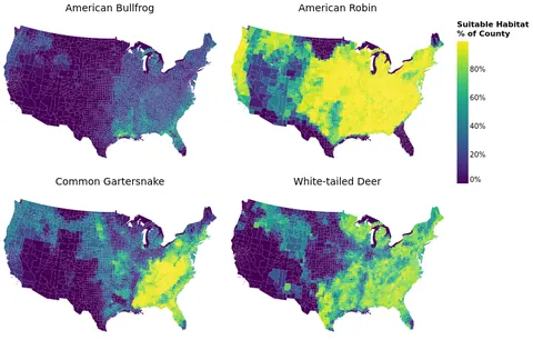 Faceted County-Level Species Habitat Maps Open in Vega Editor
 -
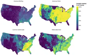 Faceted County-Level Choropleth Maps Python Source
Vega and Vega-Lite examples open in the Editor with this dataset loaded. Altair examples link to their Python source.
Provenance
- Source
- License
-
- U.S. Government Dataset (other-pd)
- File
data/species.csv· 1,034,744 bytes · View on GitHub